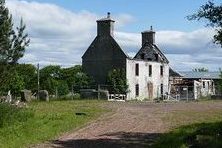
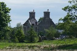
On the land at the far West Point of West Lothian, almost at the border of West Lothian and Lanarkshire, you’ll find the site of the Old Cult Estate. Although damaged by fire, Cult House still proudly stands on the site, overlooking the old Glasgow to Edinburgh Turnpike Road.
Later incorporated into expansion of the nearby Baillie Estate of Polkemmet, Cult house became a working farmhouse. For a century and a half before the farmland was open casted and re-landscaped as part of the heartlands Project.
But this Old house was so Instrumental, not only in the formation of the Town of Whitburn and the Western part of West Lothian. But also in the Global Oil Industry. But to find out how this is so, we need to go in time. Way back.
The Cult Estate & The Discovery of Petroleum
Now, If you had to stand on the site of Cult house a few thousand years ago, looking Into West Lothian towards the Bathgate hills, You’d have been looking over a huge lake. Had you come back in the 17th century, the lake would have gone, but the water hadn’t gone. Instead, the area from the edge of West Lothian by Polkemmet moor on the edge of which you stand would have been Moorland running down to a Boggy marsh that stretched right over the basin to Bathgate to the North East which would have sat on the edge of the Bog where the hills start to rise. Then right over to the east across what is now Wester Inch and on to almost Dechmont.
The Land around The Cult Estate
The land around you wouldn’t have been empty though. There would have been many little fermetouns and cottars spread over the hard land, with the land around each dug into long ridged runs for growing crops and keeping livestock etc. This type of farming is what’s called Runrig farming and had been standard practice in the Scottish Lowlands for centuries at this point.
Even the boggy marshland would have been well inhabited and laboured. The people that lived in these parts at these times had a great Influence of Flemish and Dutch Immigrants who were used to the watery issues of their low lying homelands. When we look at the little Windmills and Canals of the Netherlands, who knows how the area may have developed had not what happened next did?
The Great Improvement
In the Early 1700’s many of the landed gentry sent their sons to University in a period of history known as the ‘Scottish Enlightenment’. Many great discoveries and breakthroughs in the Science and medical fields. But also in the agricultural field too, pardon the pun. Up until this point, there were no books on farming. Only oral traditions passed on from Generation to Generation, which although sometimes worked, a lot of times they didnt. This Enlightenment changed all that.
One such student was a young gentleman named William Wardrop. Although not of farm labouring stock, he had studied the systems failings and applied Scientific theory. He purchase d the lands of Cult in 1733 and went to work in giving the landscape an entire overhaul. The Long Ridges of the Runrig fermetouns were landscaped and swept away. In place, vast square and rectangular fields were laid with stone walls and tree lined hedgerows to break the wind and work the lands irrigation system.
The Fermetouns themselves were cleared out and turned Into the Single Tenant Farms that we see today. This period of time is also known as ‘The Lowland Clearances’. Although lesser known and less forced than the ‘Highland Clearances’ these times saw a massive portion of Scotland’s population displaced. So where did all the people go? Well, many would seek work in the fast growing cities in the factories that were springing up at the daw of the Industrial revolution and some overseas. But some stayed in the area going underground to mine coal and pig Iron, starting to expand the tiny little village of Whitburn.
A New Playing Field
But it wasn’t just the people who were displaced by this agricultural revolution. The land itself was too. This new carefully structured landscape and its intricate new irrigation, had changed the surrounding land around it. No more was the water running straight down off the moor into the boggy basin where it sat stagnant. But run off into the River Almond and swept out to the sea. Thus allowing the land around it to drain and fertilise.
By the early 19th century, the Torbanehill Estate on the edge of the Western basin of the bog was Inherited by William Wardrop’s Grandson, James Wardrop. James, who was George IV’s personal Physician who travelled with him throughout his visit to Scotland. Here he had the great Torbanehill House built with an apothecary garden nearby in the grounds. The land was also rich in minerals an the Coal and Iron companies were mining the area.
But James wasn’t so much Interested in this as moved to London to pursue his Medical career. The Torbanehhill House and Estate was sold to William Gillespie in 1833. He died there in 1852 and his body returned to West Lothian where he was buried in the Kirkton Cemetery in Bathgate. Such amazing personalities of their time. Yet, despite all they achieved in their lifetime, they could not know what future discoveries lay ahead.
The Black Goldrush
One day in 1853, a couple of Farm labourers were working on the irrigation for an Iron mine in the neighbouring Boghead Estate. The found a rock that looked like coal but was more brown in colour. Also, when you put a match to It, It burned with a bright flame like hat of a candle. Carrying Out mining operations around the estate, they quickly discovered a lucrative source of this ‘Cannel Coal, or ‘Boghead Coal’. But when the mining extended to the Torbanehill estate, they discovered an even richer source of this mineral. It was much richer in Oil and became known as Torbanite. It’s unique to the area and has never been found anywhere else in the world.
A Glasgow Chemist by the name of James Young heard about this and came up from Derbyshire where he’d been experimenting with lead mines down there with oil seepage. But this blew his mind away. It was a breakthrough. With the financial Investment of the Landowner, he had the Durhamtoun Oil works erected a few hundred yards away on which now sits the Birnniehill Industrial Estate. It was here that he discovered that by heating this Torbanite in a closed retort, he could extract the shale oil from it. This he would then distil and refine into Paraffin and later petroleum.
Of course, the Torbanehhill estate wasn’t that big so the supply quickly starting to get short. Unable to find anything as superior as the Torbanite, Young proceed to mine a less potent but plentiful source of similar but not so potent mineral we now know as Shale and can see its legacy all over West Lothian in the form of the Red Shale bings. This new mineral would go on to fuel the world for the next Two centuries, where even today, we’re still running most motor vehicles on the fuel originally derived from this rock.
Agriculture to Industry.
So, when we look at they chain of events that surrounded the lands to the West and North of Whitburn we can see a link. Especially as we study the Geology of these lands. We can see how the Land Improvements made by William Wardrop throughout the Agricultural revolution of the 18th century directly impacted the discoveries made on the Torbanehhill Estate during the Industrial revolution of the 19th century.
It kinda makes you wonder what the area would look like had not these land Improvements of the 1700’s and the Lowland Clearances that followed, not happened. Perhaps it would be a vast network of canals with little Windmills in between like in Holland and Flanders. We can see why the Lowlands of Scotland had a huge amount of Flemish and Dutch settlers prior to the 18th century.