
While the modern eye is often drawn to the busy logistics hubs and motorway junctions of West Lothian, there is a forgotten history resting just beneath the surface. Located just outside the current boundaries of Whitburn, the site known as Cowhill represents a landscape of ancient roots and vanished traditions. For centuries, this area was a focal point of rural life, serving as a hub for settlement and agriculture long before the surrounding towns grew to their current size.
The Hidden History of Cowhill: Before Whitburn and the M8
In the contemporary era, Cowhill is frequently associated with the sprawling infrastructure of the Heartlands development. However, archaeological and cartographic evidence suggests that this site was once a thriving settlement of significant local importance—potentially even predating the neighboring town of Whitburn. To understand the evolution of West Lothian, one must look past the modern concrete to the medieval foundations of this historic farmstead complex.
Medieval Foundations: The Fermetoun Origins of Cowhill
The earliest recorded history of the site identifies it as a medieval “fermetoun,” a traditional Scottish communal settlement that predated the industrial urbanization of the region. A defining feature of this early landscape was the Cultrig Burn, a tributary of the River Almond that flows through the area. This watercourse would have been the lifeblood of the medieval community, providing the necessary resources for both residents and livestock.
Archaeological assessments recorded in the Sites and Monument Record (SMR) by the West of Scotland Archaeology Service (WOSAS) have identified remnants of “rig and furrow cultivation” in the vicinity. These undulating patterns in the earth are the signatures of medieval farming practices. There is a compelling argument that Cowhill formed the original backbone of the region’s layout. While Whitburn eventually became the dominant settlement, the medieval clusters like those found at the farmstead established the initial social and economic patterns of the West Lothian countryside.
Cowhill on Historical Maps
Historical mapping reveals that Cowhill was once a primary landmark, appearing with greater prominence than many of its neighbors. By analyzing records across several centuries, we can trace its transition from a strategic rural node to a substantial farmstead.
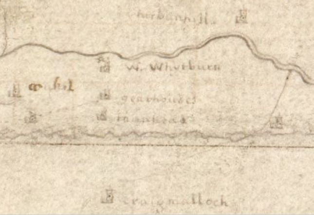
Medieval/Early Modern Records
The site is established in the SMR as a “fermetoun,” a vital hub in the pre-industrial agrarian economy.
18th-Century Maps
During this period, the site is depicted as a strategic West Lothian location. Notably, maps from the 18th and early 19th centuries often show it as a more substantial and detailed complex than the fledgling settlement of Whitburn.
19th-Century OS Maps
The 1st edition Ordnance Survey map (mid-19th century) illustrates Cowhill as a well-established farmstead complex, serving as a key landmark for travelers and residents.
Agriculture and Discoveries
As the centuries progressed, the site evolved into a thriving working farmstead. The lands were not only agriculturally productive but also held hidden indicators of the area’s long-term human presence. A significant archaeological discovery occurred in 1921, when a coin hoard was unearthed by a farmer while ploughing the fields of the farm. This find provides tangible evidence of economic activity and suggests that residents felt the need to cache wealth on these grounds long ago.
The farmstead did not exist in a vacuum; it was the heart of a dense agricultural network. The SMR identifies several other historic farmsteads in the immediate vicinity that shared this landscape:
- Righouse
- Brownhill
- Heads
- Cultrig Bent
- East Cult
- Turnhigh (also known as Burnside)
Together, these sites formed the social fabric of the area before the 19th and 20th centuries brought the heavy industry of the Polkemmet Colliery and other mining ventures to the doorstep of the farm.
From Farmstead to Heartlands
In the late 20th and early 21st centuries, the landscape underwent a radical transformation as the site was incorporated into the “Heartlands Development Area” (identified as EOI-0001 in West Lothian Council reports). This major regeneration project sought to transition the land from its industrial and agricultural past into a hub for housing, employment, and recreation.
While much of the surrounding area suffered “substantial disturbance” from the operations of the former Polkemmet Colliery and more recent opencast mining, the story of the farmstead is not entirely lost. Current council reports indicate that the site is now preferred for a new golf course and open space, a use considered well-suited to the topography and landscape setting.
Crucially, while modern infrastructure like the M8 Junction 4 has altered the terrain, WOSAS notes that material associated with Cowhill and its neighboring farmsteads may survive within the substantial areas of greenfield ground that escaped large-scale mining disturbance. Because these areas retain the potential for buried sub-surface deposits, a programme of archaeological evaluation trenching would be required in advance of any further development to preserve the remaining fragments of this ancient settlement.
Preserving the Memory of Cowhill
The story of Cowhill serves as a vital reminder of the historical layers that exist beneath West Lothian’s modern developments. From its origins as a medieval Fermetoun on the banks of the Cultrig Burn to the discovery of a 20th-century coin hoard, it has been a constant presence in the evolution of the Scottish countryside. While the physical farm has been superseded by the “Heartlands” vision, the potential for archaeological survival means its legacy remains a tangible part of our heritage. Recognizing these forgotten sites allows us to maintain a connection to the social and architectural roots that predated the industrial age.
Archaeological findings
In 1921, a significant coin hoard was discovered by a farmer while ploughing the lands of Cowhill farm. These were 244 Silver coins dating from around the late 14th century to Early 15th century. The coins showed the heads of several different Kings, both Scottish and English, ranging over about 80 years These were Robert II and III of Scotland, James I, II, III and IV of Scotland, Edward III of England and Henry V and VI of England.
The hoard is speculated to be some sort of War Pension. This discovery, recorded in the regional SMR, offers a rare glimpse into the long-term economic history and human occupation of this historic West Lothian site. Another finding of Two Roman Coins which were found in a nearby boggy patch. However, there isn’t much other sign of Roman occupation of the area. But there’s a good chance a few would have wandered and would have no doubt between many in the area and dropped their coins whatever they were doing.