
Nestled high in the Bathgate Hills along Drumcross Road, Galabraes Farm appears at first glance to be a traditional West Lothian pastoral steading. Yet beneath its grazing pastures and rubble-stone walls lies a multi-millennial timeline that bridges Scotland’s prehistoric ritual landscape with the agricultural revolutions of the 18th and 19th centuries.
The Galabraes Farm
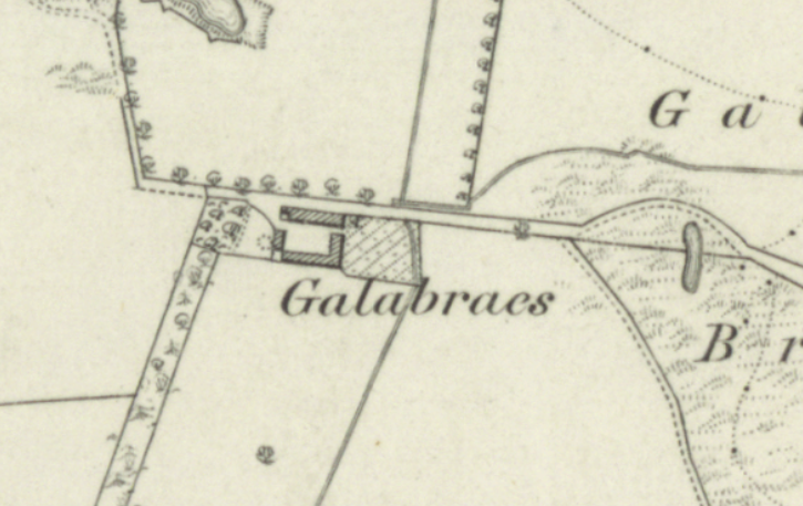
For history enthusiasts, local hikers, and archaeology buffs exploring West Lothian, Galabraes represents one of the most intriguing historical sites near Bathgate—where Bronze Age burials meet the enduring heritage of Scottish farming.
The Galabraes Standing Stones
Long before ploughs touched the soil of Galabraes, the ridge was a sacred site. Situated at an elevation of approximately 265 metres (870 feet) above sea level, the farmland is home to the Galabraes Standing Stone (also known as Gala Braes Menhir), a designated Scheduled Monument by Historic Environment Scotland (SM6184).
The primary monolith, carved from local whinstone, stands roughly 1.6 metres (5.2 feet) tall and tapers toward its summit. It occupies a commanding position on the crown of the ridge, offering sweeping panoramic views across the central valley of Scotland. On clear days, the vista stretches westward all the way to the peak of Goatfell on the Isle of Arran.
| Prehistoric Feature | Details | Archaeological Significance |
| Stone A (Main Monolith) | 1.6m tall whinstone slab | Surviving Later Neolithic / Bronze Age ritual marker |
| Stone B (The Stump) | Located ~70m to the west | Indicates a larger, multi-stone ceremonial complex |
| Elevation & Sightlines | 265m above sea level | Aligned with prominent regional landmarks and valleys |
Archaeological evidence shows this stone did not stand alone. Approximately 70 metres to the west lies the stump of a second monolith (“Stone B”) on a small sand-hillock. Though broken and re-erected in mortar during the early 20th century, the presence of multiple stones strongly suggests that Galabraes was once a complex prehistoric ceremonial site rather than a simple territorial boundary marker.
A Sacred Gateway to Cairnpapple Hill
To understand why ancient communities erected massive stone monuments at Galabraes, one must look 1.9 kilometres north to Cairnpapple Hill—one of mainland Scotland’s most important Neolithic and Bronze Age ritual sites.
Because Cairnpapple sits directly north when viewing between the two Galabraes stones, archaeo-historians and local researchers propose that the Galabraes ridge acted as a ceremonial waymarker or gateway. Pilgrims and travelers ascending from the lowlands of Bathgate would have used the standing stones of Galabraes to guide their path toward the sacred summit of Cairnpapple during seasonal rites and burial ceremonies.
Bones Beneath the Stone
The funerary purpose of Galabraes was confirmed through a chance agricultural discovery. Many years prior to 1902, the father of Mr. Carlaw, then the tenant farmer of Gala Braes Farm, was undertaking excavation work around the base of the primary standing stone. During the dig, he unearthed human bones buried directly beneath the monolith.
This discovery formally categorized Galabraes as a Bronze Age or Later Neolithic burial site. In prehistoric Scotland, standing stones were frequently erected over cist burials or cremation pits to honor elite ancestors and anchor a community’s spiritual claim to the surrounding landscape.
The “Clinkin Stane” Misconception
When researching the history of Galabraes Farm, local historians often encounter a persistent case of mistaken identity involving the “Clinkin Stane.”
It is common in local Bathgate folklore for residents to refer to the Galabraes Standing Stone as the Clinkin Stane—but historical records prove this is factually incorrect. The true Clinkin Stane was an entirely separate monolith that once stood beside the nearby (now ruined) Clinkin Stane Cottages.
Around 1837, a former tenant farmer who viewed the ancient stone as an agricultural obstruction dynamited and removed the true Clinkin Stane. Because the Galabraes monolith survived intact on the neighboring ridge, folk memory gradually transferred the famous “Clinkin” moniker onto the surviving stone at Galabraes.
The Agricultural Revolution
While prehistory defined the soil of Galabraes, the 18th and 19th centuries shaped the physical farmstead we recognize today. During the Scottish Agricultural Revolution, the Bathgate Hills transitioned from open, unimproved moorland and subsistence holdings into structured, highly productive tenant farms.
Architectural Evolution of Galabraes
Like many steadings surveyed across the Bathgate Hills, Galabraes Farm was constructed using locally quarried whinstone and rubble walling. The farm’s layout reflects the progressive agricultural techniques of the Victorian era:
The Shift to Cattle Courts:
Early linear or L-shaped cottages were expanded into enclosed courtyard steadings. This design allowed cattle to be sheltered and fed centrally during West Lothian’s harsh winters.
Dairying Innovation:
Positioned on the transitional zone between upland grazing and lowland arable farming. Steadings like Galabraes adapted heavily to dairy production and livestock rearing. Thatched roofs were universally replaced with durable imported slate and ventilated tiles to keep byres hygienic for dairy processing.
Estate Patronage:
During the 1830s and 1840s—a boom period for Scottish agriculture—surrounding estates heavily invested in upgrading farm infrastructure, leaving an indelible architectural “historical narrative” in the stonework of steadings across the district.
Visiting Galabraes Today
For those exploring the heritage of West Lothian, Galabraes Farm remains a working agricultural landscape. The site can be viewed by traveling east from Bathgate along Drumcross Road, passing the Petershill Nature Reserve. As the road rises into the Bathgate Hills, Galabraes Farm sits to the north, with the ancient standing stone breaking the horizon on the left-hand ridge.